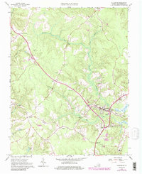
1965 Map of Gloucester
USGS Topo · Published 1986About this map
Gloucester stands as the central hub of this Middle Peninsula landscape, shown here as it transitioned through the mid-20th century. The map illustrates a dense network of spiritual and social centers, featuring numerous rural houses of worship such as Petsworth Ch, Zion Poplars Ch, and Locust Grove Ch. The low-lying terrain is defined by the winding paths of Beaverdam Swamp and Woods Mill Swamp, which shaped the placement of early settlements and road crossings. These natural drainage patterns created distinct peninsulas like Cowpen Neck and Deacons Neck. Beyond the county seat, small crossroads communities such as Woods Crossroads, Sassafras, and Belroi appear connected by a maturing highway system. Infrastructure of the era is evident in the presence of the Gloucester Airport and a Gaging Station, while traditional landmarks like Fiddlers Bridge anchor the local geography.
Find a feature on this map
48 named features on this map. Tap any name to fly to it.
Don’t see what you’re looking for? This feature index may not catch every label — zoom into the map to look around manually.
Map Details
Editions of this 1965 Gloucester Map
4 editions found
Other maps of this area

1906 · Williamsburg
USGS Topo · 1:62,500

1916 · Kilmarnock
USGS Topo · 1:48,000

1916 · Mathews
USGS Topo · 1:62,500

1917 · Urbanna
USGS Topo · 1:62,500

1917 · Kilmarnock
USGS Topo · 1:62,500

1917 · Mathews
USGS Topo · 1:62,500

1942 · Kilmarnock
USGS Topo · 1:62,500

1943 · Richmond
USGS Topo · 1:250,000

1948 · Ware Neck
USGS Topo · 1:24,000

1948 · Achilles
USGS Topo · 1:24,000