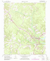
1965 Map of Gloucester
USGS Topo · Published 1986About this map
Gloucester serves as the focal point of this coastal Virginia landscape, where the town's expansion toward Edgehill is clearly visible against the rural backdrop of the mid-1960s. The map captures a high density of community landmarks, particularly country churches like Shepherdsville Ch, Zion Hill Ch, and the historic Zion Poplars Ch, which reflect the deep-rooted social fabric of the Tidewater region. The interior is defined by extensive wetlands, notably Beaverdam Swamp and Beech Swamp, which dictated the layout of early settlements such as Ark, Sassafras, and Woods Crossroads. Small-scale infrastructure of the era, including the Gloucester Airport, the Fiddlers Bridge crossing, and a Gaging Station on the swamp, provides evidence of how the local economy and transportation network were managed before later decades of more intensive development.
Find a feature on this map
45 named features on this map. Tap any name to fly to it.
Don’t see what you’re looking for? This feature index may not catch every label — zoom into the map to look around manually.
Map Details
Editions of this 1965 Gloucester Map
4 editions found
Other maps of this area

1906 · Williamsburg
USGS Topo · 1:62,500

1916 · Kilmarnock
USGS Topo · 1:48,000

1916 · Mathews
USGS Topo · 1:62,500

1917 · Urbanna
USGS Topo · 1:62,500

1917 · Kilmarnock
USGS Topo · 1:62,500

1917 · Mathews
USGS Topo · 1:62,500

1942 · Kilmarnock
USGS Topo · 1:62,500

1943 · Richmond
USGS Topo · 1:250,000

1948 · Ware Neck
USGS Topo · 1:24,000

1948 · Achilles
USGS Topo · 1:24,000