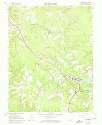
1965 Map of Gloucester
USGS Topo · Published 1974About this map
Gloucester serves as the central hub of this Tidewater landscape, where the colonial-era Ware Ch and modern additions like the Gloucester Airfield coexist within a network of creek-fed swamplands. The map records a rural community deeply tied to its landmarks, from the Lookout Tower near Ark to the historic Zion Poplars and Petsworth Ch. Small settlements such as Belroi, Sassafras, and Woods Crossroads are connected by winding roads that cross waterways like Beaverdam Swamp and Fox Mill Run. Revisions from 1973 aerial photography are clearly visible in purple, showing the expansion of local infrastructure, including a Trailer Park and new residential developments around Edgehill. The density of country churches, including Bethel Ch and Locust Grove Ch, along with schools like Walker Sch, provides a detailed record for genealogists researching the social fabric of Gloucester County in the mid-20th century.
Find a feature on this map
50 named features on this map. Tap any name to fly to it.
Don’t see what you’re looking for? This feature index may not catch every label — zoom into the map to look around manually.
Map Details
Editions of this 1965 Gloucester Map
4 editions found
Other maps of this area

1906 · Williamsburg
USGS Topo · 1:62,500

1916 · Kilmarnock
USGS Topo · 1:48,000

1916 · Mathews
USGS Topo · 1:62,500

1917 · Urbanna
USGS Topo · 1:62,500

1917 · Kilmarnock
USGS Topo · 1:62,500

1917 · Mathews
USGS Topo · 1:62,500

1942 · Kilmarnock
USGS Topo · 1:62,500

1943 · Richmond
USGS Topo · 1:250,000

1948 · Ware Neck
USGS Topo · 1:24,000

1948 · Achilles
USGS Topo · 1:24,000