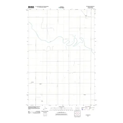
2011 Map of Glover
USGS Topo · Published 2011About this map
The James River snakes across this prairie landscape in a series of sharp, recursive loops, defining the geography of eastern Dickey County. Small communities and rural gathering points are scattered across the section-line road grid, including the settlement of Glover in the northeast and Clement to the southwest. The presence of the Norwegian Cemetery reflects the deep Scandinavian heritage of the region's early homesteaders, while the community of Norway further south underscores this cultural lineage. Modern rural infrastructure is evidenced by the Pfeifer Airstrip, located near the southern boundary. The map illustrates a strictly organized agricultural landscape where the organic path of the river provides the only deviation from the relentless geometry of the township and range survey system.
Find a feature on this map
20 named features on this map. Tap any name to fly to it.
Don’t see what you’re looking for? This feature index may not catch every label — zoom into the map to look around manually.
Map Details
Editions of this 2011 Glover Map
This is the sole edition of this map. No revisions or reprints were ever made.
Other maps of this area

1894 · La Moure
USGS Topo · 1:62,500

1894 · Fullerton
USGS Topo · 1:62,500

1894 · Oakes
USGS Topo · 1:62,500

1895 · Lamoure
USGS Topo · 1:125,000

1918 · La Moure
USGS Topo · 1:125,000

1952 · Glover
USGS Topo · 1:24,000

1952 · Oakes
USGS Topo · 1:24,000

1952 · Independence
USGS Topo · 1:24,000

1953 · Jamestown
USGS Topo · 1:250,000
1955 · Oakes SE
USGS Topo · 1:24,000