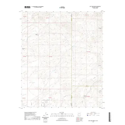
2020 Map of Goat Camp Spring
USGS Topo · Published 2020About this map
The high-desert terrain of the Arizona-New Mexico state line dominates this modern topographical survey, where the convergence of Greenlee, Grant, and Hidalgo counties meets a network of intermittent washes. Small-scale residential development is concentrated at Hunter Flat in the southwest corner, defined by local roads such as Chaparrel St and Mesquite Ave. The landscape is etched by drainage systems including Sand Wash and Bitter Creek, which cut through a series of canyons such as Daniels Camp Canyon and Iron Canyon. Notable elevations like Vanderbilt Peak and Charlie Hill provide distinct landmarks across the township grids. This 2020 map documents the contemporary land use of this border region, showing how modern infrastructure like Carlisle Rd navigates the older geography of established water sources like Goat Camp Spring and Mulberry Spring.
Find a feature on this map
38 named features on this map. Tap any name to fly to it.
Don’t see what you’re looking for? This feature index may not catch every label — zoom into the map to look around manually.
Map Details
Editions of this 2020 Goat Camp Spring Map
This is the sole edition of this map. No revisions or reprints were ever made.
Other maps of this area

1954 · Silver City
USGS Topo · 1:250,000

1958 · Silver City
USGS Topo · 1:250,000

1959 · Steeple Rock
USGS Topo · 1:62,500

1959 · Canador Peak
USGS Topo · 1:62,500

1959 · York Valley
USGS Topo · 1:62,500

1960 · Duncan
USGS Topo · 1:62,500

1962 · Silver City
USGS Topo · 1:250,000
1986 · Sheldon
USGS Topo · 1:24,000
1986 · Duncan
USGS Topo · 1:24,000
1986 · Tillie Hall Peak
USGS Topo · 1:24,000