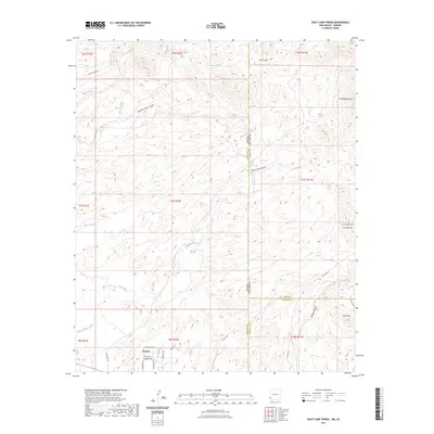
2023 Map of Goat Camp Spring
USGS Topo · Published 2023About this map
Duncan and the residential area of Hunter Flat anchor the southern reaches of this landscape where the borders of Arizona and New Mexico meet. The terrain is defined by a dense network of arid drainages, including Sand Wash, Harris Wash, and Waters Wash, which carve through the high desert. Local landmarks such as Vanderbilt Peak, Charlie Hill, and the prominent Rim Rock provide navigation points across the broken topography of Carlisle Canyon and Iron Canyon.
Find a feature on this map
43 named features on this map. Tap any name to fly to it.
Don’t see what you’re looking for? This feature index may not catch every label — zoom into the map to look around manually.
Map Details
Editions of this 2023 Goat Camp Spring Map
This is the sole edition of this map. No revisions or reprints were ever made.
Other maps of this area

1954 · Silver City
USGS Topo · 1:250,000

1958 · Silver City
USGS Topo · 1:250,000

1959 · Steeple Rock
USGS Topo · 1:62,500

1959 · Canador Peak
USGS Topo · 1:62,500

1959 · York Valley
USGS Topo · 1:62,500

1960 · Duncan
USGS Topo · 1:62,500

1962 · Silver City
USGS Topo · 1:250,000
1986 · Sheldon
USGS Topo · 1:24,000
1986 · Duncan
USGS Topo · 1:24,000
1986 · Tillie Hall Peak
USGS Topo · 1:24,000