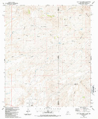
1986 Map of Goat Camp Spring
USGS Topo · Published 1987About this map
Hunter Flat and the edges of Duncan anchor the southwestern corner of this survey, where the desert floor meets the rising slopes of the Summit Mountains. The landscape is defined by its drainage systems and mining history, with numerous Mine and Mines symbols scattered through the complex canyon networks of Iron Canyon and Goat Camp Canyon. Strategic water sources like Goat Camp Spring and Mulberry Spring were essential for the small-scale operations and livestock grazing indicated by the Corrals found along Sand Wash.
Find a feature on this map
28 named features on this map. Tap any name to fly to it.
Don’t see what you’re looking for? This feature index may not catch every label — zoom into the map to look around manually.
Map Details
Editions of this 1986 Goat Camp Spring Map
This is the sole edition of this map. No revisions or reprints were ever made.
Other maps of this area

1954 · Silver City
USGS Topo · 1:250,000

1958 · Silver City
USGS Topo · 1:250,000

1959 · Steeple Rock
USGS Topo · 1:62,500

1959 · Canador Peak
USGS Topo · 1:62,500

1959 · York Valley
USGS Topo · 1:62,500

1960 · Duncan
USGS Topo · 1:62,500

1962 · Silver City
USGS Topo · 1:250,000
1986 · Sheldon
USGS Topo · 1:24,000
1986 · Duncan
USGS Topo · 1:24,000
1986 · Tillie Hall Peak
USGS Topo · 1:24,000