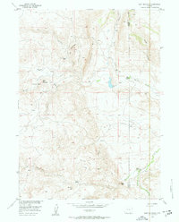
1955 Map of Goat Mountain
USGS Topo · Published 1957About this map
Iron Mountain and the Limestone Rim dominate this high-altitude landscape along the border of Albany and Laramie Counties. The area is defined by its mid-1950s ranching economy and mineral potential, with several prominent homesteads including Bell Ranch, Bosler Ranch, and Indian Guide Ranch scattered across the drainages. A significant geological feature of the map is the concentration of Titaniferous Deposits and a specific Titaniferous Prospect Area south of Goat Mountain, indicating the industrial interest in the region's mineral wealth during the post-war era. Water flows through the network of the Chugwater Creek system, including the Middle Chugwater Creek and South Chugwater Creek. These drainages create natural corridors between high points like Dummy Hill and Eagle Top, providing a detailed look at the land use patterns of Wyoming’s mountain-and-basin topography.
Find a feature on this map
32 named features on this map. Tap any name to fly to it.
Don’t see what you’re looking for? This feature index may not catch every label — zoom into the map to look around manually.
Map Details
Editions of this 1955 Goat Mountain Map
3 editions found
Other maps of this area

1905 · Sherman
USGS Topo · 1:125,000

1948 · Ragged Top Mountain
USGS Topo · 1:62,500

1950 · Ragged Top Mountain
USGS Topo · 1:62,500

1954 · Cheyenne
USGS Topo · 1:250,000

1955 · Indian Guide
USGS Topo · 1:24,000

1955 · Baldy Mountain
USGS Topo · 1:24,000

1955 · Sheep Rock
USGS Topo · 1:24,000

1955 · Goat Mountain
USGS Topo · 1:24,000

1958 · Cheyenne
USGS Topo · 1:250,000

1962 · Horse Creek
USGS Topo · 1:24,000