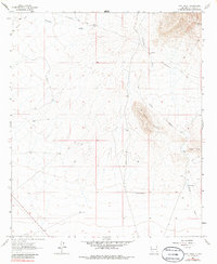
1964 Map of Goat Ridge
USGS Topo · Published 1986About this map
Butterfield Trail winds through this arid expanse of Luna County, tracing a historic path of westward expansion across the New Mexico desert. The landscape is defined by the prominent uplift of Goat Ridge and the nearby Fluorite Ridge, where the terrain's geological character is punctuated by drainage systems like Porter Draw and China Draw. The scarcity of water in this environment is evident through the reliance on scattered infrastructure, including Wilson Reservoir, China Tank, and isolated points like Butterfield Well and Prospect Spring.
Find a feature on this map
18 named features on this map. Tap any name to fly to it.
Don’t see what you’re looking for? This feature index may not catch every label — zoom into the map to look around manually.
Map Details
Editions of this 1964 Goat Ridge Map
2 editions found
Other maps of this area

1899 · Deming
USGS Topo · 1:125,000

1915 · Deming
USGS Topo · 1:125,000

1955 · Las Cruces
USGS Topo · 1:250,000

1956 · Dwyer
USGS Topo · 1:62,500

1958 · Las Cruces
USGS Topo · 1:250,000

1962 · Lake Valley
USGS Topo · 1:62,500

1964 · Goat Ridge
USGS Topo · 1:24,000
1964 · Spalding
USGS Topo · 1:24,000

1964 · Deming West
USGS Topo · 1:24,000

1964 · Massacre Peak
USGS Topo · 1:24,000