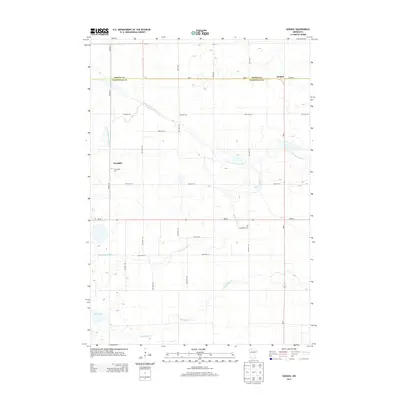
2013 Map of Godahl
USGS Topo · Published 2013About this map
Godahl and Sveadahl anchor this rural landscape along the border of Brown and Watonwan counties. The terrain is defined by the winding course of the N Fork Watonwan River as it joins the main Watonwan River, creating a network of riparian corridors across the agricultural grid. To the south, Butterfield Cr meanders toward the eastern edge of the quadrangle, while Ewy Lake provides a distinct hydrological landmark in the southwest corner. Genealogists will find particular value in the presence of two historic burial sites, E Sveadahl Cem and W Sveadahl Cem, which reflect the early Scandinavian settlement patterns of this prairie region. A dense system of township and county roads, including MN-30 and MN-4, connects the scattered farmsteads that characterize this portion of southern Minnesota.
Find a feature on this map
30 named features on this map. Tap any name to fly to it.
Don’t see what you’re looking for? This feature index may not catch every label — zoom into the map to look around manually.
Map Details
Editions of this 2013 Godahl Map
This is the sole edition of this map. No revisions or reprints were ever made.
Other maps of this area

1953 · New Ulm
USGS Topo · 1:250,000

1954 · Fairmont
USGS Topo · 1:250,000

1957 · New Ulm
USGS Topo · 1:250,000

1958 · New Ulm
USGS Topo · 1:250,000

1958 · Fairmont
USGS Topo · 1:250,000

1967 · New Ulm
USGS Topo · 1:250,000

1967 · Lake Hanska West
USGS Topo · 1:24,000

1967 · Godahl
USGS Topo · 1:24,000

1967 · Darfur
USGS Topo · 1:24,000
1967 · Lake Hanska East
USGS Topo · 1:24,000