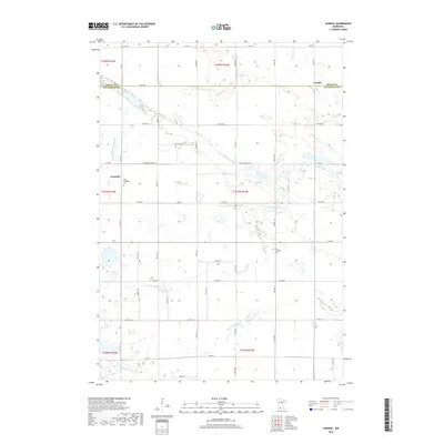
2019 Map of Godahl
USGS Topo · Published 2019About this map
The Watonwan River and its N Fork Watonwan River meander through this agricultural landscape at the border of Brown and Watonwan Counties. This map documents a quiet rural region defined by dispersed settlements and a grid of township roads. The community of Sveadahl serves as a local anchor, flanked by its namesake burial grounds, West Sveadahl Cem and East Sveadahl Cem. These sites, along with the nearby village of Godahl, reflect the enduring Swedish-American heritage of the South Central Minnesota prairies. The drainage patterns of Butterfield Cr and various unnamed wetlands reveal the subtle topography of the basin, illustrating the intersection of natural watercourses and the section-line roads that have organized this territory since its initial survey.
Find a feature on this map
50 named features on this map. Tap any name to fly to it.
Don’t see what you’re looking for? This feature index may not catch every label — zoom into the map to look around manually.
Map Details
Editions of this 2019 Godahl Map
This is the sole edition of this map. No revisions or reprints were ever made.
Other maps of this area

1953 · New Ulm
USGS Topo · 1:250,000

1954 · Fairmont
USGS Topo · 1:250,000

1957 · New Ulm
USGS Topo · 1:250,000

1958 · New Ulm
USGS Topo · 1:250,000

1958 · Fairmont
USGS Topo · 1:250,000

1967 · New Ulm
USGS Topo · 1:250,000

1967 · Lake Hanska West
USGS Topo · 1:24,000

1967 · Godahl
USGS Topo · 1:24,000

1967 · Darfur
USGS Topo · 1:24,000
1967 · Lake Hanska East
USGS Topo · 1:24,000