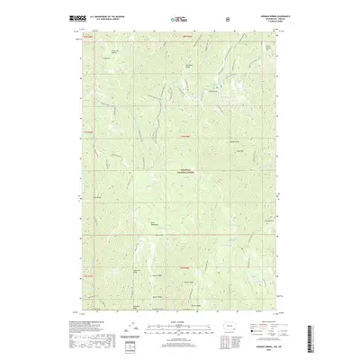
2020 Map of Godman Spring
USGS Topo · Published 2020About this map
Umatilla National Forest encompasses this high-elevation landscape within the Blue Mountains, where the 2020 terrain is defined by a dense network of ridgelines and drainage basins. The area is characterized by significant topographic relief, with prominent features like Sawtooth Ridge, Beaver Ridge, and Dexter Ridge separating the deep-cut valleys of the N Fork Touchet River and Slick Ear Cr. Transportation through this wilderness relies on a combination of seasonal routes such as the Kendall Skyline Road and an extensive trail system, including the Sawtooth Trail and Middle Point Ridge Trail. The presence of numerous water sources like Godman Spring, Stayawhile Spring, and Wildcat Spring highlights the area's importance for local hydrology and recreation, while Ski Bluewood sits at the western edge of the map, marking a primary point of access for visitors.
Find a feature on this map
67 named features on this map. Tap any name to fly to it.
Don’t see what you’re looking for? This feature index may not catch every label — zoom into the map to look around manually.
Map Details
Editions of this 2020 Godman Spring Map
This is the sole edition of this map. No revisions or reprints were ever made.
Other maps of this area

1937 · Pomeroy
USGS Topo · 1:96,000

1942 · Pomeroy
USGS Topo · 1:125,000

1955 · Pullman
USGS Topo · 1:250,000

1955 · Grangeville
USGS Topo · 1:250,000

1958 · Pullman
USGS Topo · 1:250,000

1959 · Grangeville
USGS Topo · 1:250,000
1967 · Robinette Mtn.
USGS Topo · 1:24,000

1967 · Elbow Creek
USGS Topo · 1:24,000
1967 · Bone Spring
USGS Topo · 1:24,000

1967 · Oregon Butte
USGS Topo · 1:24,000