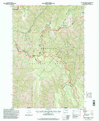
1995 Map of Godman Spring
USGS Topo · Published 1998About this map
Umatilla National Forest and the Wenahatucannon Wilderness dominate this high-country landscape along the Washington-Oregon border. The map documents a rugged interior network of ridge-top paths and timberline outposts, centered on the Godman Guard Station and the recreational development at Ski Bluewood. This area serves as a critical watershed, with the North Fork Touchet River and the North Fork Wenaha River draining deeply incised canyons.
Find a feature on this map
60 named features on this map. Tap any name to fly to it.
Don’t see what you’re looking for? This feature index may not catch every label — zoom into the map to look around manually.
Map Details
Editions of this 1995 Godman Spring Map
This is the sole edition of this map. No revisions or reprints were ever made.
Other maps of this area

1937 · Pomeroy
USGS Topo · 1:96,000

1942 · Pomeroy
USGS Topo · 1:125,000

1955 · Pullman
USGS Topo · 1:250,000

1955 · Grangeville
USGS Topo · 1:250,000

1958 · Pullman
USGS Topo · 1:250,000

1959 · Grangeville
USGS Topo · 1:250,000
1967 · Robinette Mtn.
USGS Topo · 1:24,000

1967 · Elbow Creek
USGS Topo · 1:24,000
1967 · Bone Spring
USGS Topo · 1:24,000

1967 · Oregon Butte
USGS Topo · 1:24,000