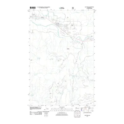
2011 Map of Gold Bar
USGS Topo · Published 2011About this map
Skykomish River and Wallace River converge near the established town of Gold Bar, where the grid of residential streets like Lewis Ave and Orchard Ave meet the riverbanks. The local geography is defined by its water systems and the rising topography to the south, including Haystack Mountain and its Haystack Lookout. Smaller settlements like Startup and May Creek are clustered along the river corridor, linked by the Wallace River Bridge. Higher elevations reveal a series of isolated water bodies such as Airplane Lake, Haleyon Lake, and Winter Lake. The transition from the valley floor to the timbered heights is marked by the presence of Camp Huston and the dramatic drop of Wallace Falls to the north, illustrating the region's reliance on the watershed for both settlement and industry.
Find a feature on this map
71 named features on this map. Tap any name to fly to it.
Don’t see what you’re looking for? This feature index may not catch every label — zoom into the map to look around manually.
Map Details
Editions of this 2011 Gold Bar Map
This is the sole edition of this map. No revisions or reprints were ever made.
Other maps of this area

1921 · Sultan
USGS Topo · 1:125,000

1923 · Sultan
USGS Topo · 1:125,000

1953 · Sultan
USGS Topo · 1:24,000

1953 · Lake Joy
USGS Topo · 1:24,000

1956 · Monroe
USGS Topo · 1:62,500

1957 · Index
USGS Topo · 1:62,500

1957 · Wenatchee
USGS Topo · 1:250,000

1960 · Mount Si
USGS Topo · 1:62,500
1975 · Skykomish River
USGS Topo · 1:100,000
1986 · Lake Joy
USGS Topo · 1:24,000