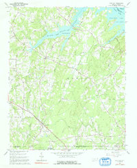
1962 Map of Gold Hill
USGS Topo · Published 1992About this map
Gold Hill stands as the primary settlement on this map of the North Carolina Piedmont, situated where the Southern railway cuts through the southern reaches of the quadrangle. The landscape is defined by the convergence of several county lines, where Rowan, Cabarrus, and Stanly meet. This rural topography is heavily carved by the Yadkin River and the expanding waters of High Rock Lake, which dominate the northern and eastern margins. The map captures a moment when traditional land access relied on a network of ferry-named routes like Bringle Ferry Road and Stokes Ferry Road, reflecting the area's historical reliance on river crossings.
Find a feature on this map
49 named features on this map. Tap any name to fly to it.
Don’t see what you’re looking for? This feature index may not catch every label — zoom into the map to look around manually.
Map Details
Editions of this 1962 Gold Hill Map
3 editions found
Other maps of this area

1949 · High Rock
USGS Topo · 1:24,000

1949 · Denton NW
USGS Topo · 1:24,000

1953 · Charlotte
USGS Topo · 1:250,000

1954 · Charlotte
USGS Topo · 1:250,000

1957 · Mount Pleasant
USGS Topo · 1:62,500

1957 · Albemarle
USGS Topo · 1:62,500

1957 · Denton
USGS Topo · 1:62,500

1960 · Charlotte
USGS Topo · 1:250,000

1962 · Charlotte
USGS Topo · 1:250,000

1962 · Southmont
USGS Topo · 1:24,000