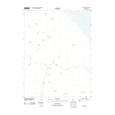
2010 Map of Gold Hill
USGS Topo · Published 2010About this map
Gold Hill and its surrounding desert mining landscape appear here in the early 21st century, centered on the historic mining district in the shadow of Dutch Mountain. The map reveals a dense network of extraction sites including the Alvarado Mine, United States Mine, and the Garrison Mines located to the north near Wilson Hill. This region is defined by its arid drainage patterns, with Gold Hill Wash and Rodenhouse Wash cutting across the basin, punctuated by critical water sources like Cane Spring and Ochre Springs. Transport into this remote corner of Tooele County relies on a few primary routes, notably Gold Hill Rd and Callao Rd, which connect the scattered operations. The distribution of sites like Silver Hill Mine and Stardust Mine suggests a long history of mineral exploration throughout the diverse terrain of Accident Canyon and Spotted Fawn Canyon.
Find a feature on this map
27 named features on this map. Tap any name to fly to it.
Don’t see what you’re looking for? This feature index may not catch every label — zoom into the map to look around manually.
Map Details
Editions of this 2010 Gold Hill Map
This is the sole edition of this map. No revisions or reprints were ever made.
Other maps of this area

1925 · Gold Hill
USGS Topo · 1:62,500

1928 · Gold Hill
USGS Topo · 1:62,500

1953 · Tooele
USGS Topo · 1:250,000

1955 · Tooele
USGS Topo · 1:250,000

1972 · Elephant Knoll
USGS Topo · 1:24,000

1972 · Elephant Knoll SE
USGS Topo · 1:24,000
1973 · Ochre Mountain
USGS Topo · 1:24,000
1973 · Gold Hill
USGS Topo · 1:24,000
1973 · Ibapah
USGS Topo · 1:24,000

1973 · Gold Hill 1 SW
USGS Topo · 1:24,000