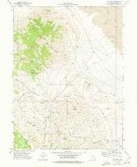
1973 Map of Gold Hill
USGS Topo · Published 1977About this map
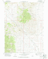
Gold Hill and the surrounding high desert of Tooele County are defined by a dense network of mining claims and rugged terrain in the early 1970s. The landscape is dominated by Dutch Mountain to the northwest and several smaller peaks including Woodman Peak and Lucky Day Knob. Prospectors and historians will find a high concentration of operations such as the Garrison Mines, Dutch Mine, and the Stardust Mine, illustrating the extensive silver and gold mining history of the Deep Creek Range. Water sources are scarce in this arid environment, making features like Cane Spring and Ochre Springs critical landmarks for the area's development. A complex system of access routes, including numerous Jeep Trails and unnamed secondary roads, connect the scattered mining sites to the main settlement. To the northeast, the terrain levels out into the Mud Flat, contrasting with the deeply incised drainages of Royal Gulch and Tribune Gulch.
Find a feature on this map
31 named features on this map. Tap any name to fly to it.
Don’t see what you’re looking for? This feature index may not catch every label — zoom into the map to look around manually.
Map Details
Editions of this 1973 Gold Hill Map
2 editions found
Other maps of this area

1925 · Gold Hill
USGS Topo · 1:62,500

1928 · Gold Hill
USGS Topo · 1:62,500

1953 · Tooele
USGS Topo · 1:250,000

1955 · Tooele
USGS Topo · 1:250,000

1972 · Elephant Knoll
USGS Topo · 1:24,000

1972 · Elephant Knoll SE
USGS Topo · 1:24,000
1973 · Ochre Mountain
USGS Topo · 1:24,000
1973 · Ibapah
USGS Topo · 1:24,000

1973 · Gold Hill 1 SW
USGS Topo · 1:24,000
1973 · Clifton
USGS Topo · 1:24,000