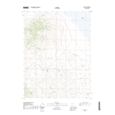
2023 Map of Gold Hill
USGS Topo · Published 2023About this map
Gold Hill and the surrounding high desert of Tooele County are defined by a complex geography of mining-era landmarks and arid terrain. This 2023 survey details the prominence of Dutch Mountain and Woodman Peak, which overlook a network of primitive access routes such as Lower Little Valley Rd and Cane Spring Rd. The transition from the steep relief of Royal Gulch and Accident Canyon to the vast, level expanse of the Great Salt Lake Desert in the northeast corner illustrates the stark environmental shift characteristic of this region. Local water sources, crucial in this dry landscape, are marked at Cane Spring and Ochre Springs. Named features like Lucky Day Knob and Spotted Fawn Canyon reflect the prospecting history that once shaped the area, while the drainage patterns of Gold Hill Wash and Rodenhouse Wash show the natural hydrology flowing toward the salt flats.
Find a feature on this map
26 named features on this map. Tap any name to fly to it.
Don’t see what you’re looking for? This feature index may not catch every label — zoom into the map to look around manually.
Map Details
Editions of this 2023 Gold Hill Map
This is the sole edition of this map. No revisions or reprints were ever made.
Other maps of this area

1925 · Gold Hill
USGS Topo · 1:62,500

1928 · Gold Hill
USGS Topo · 1:62,500

1953 · Tooele
USGS Topo · 1:250,000

1955 · Tooele
USGS Topo · 1:250,000

1972 · Elephant Knoll
USGS Topo · 1:24,000

1972 · Elephant Knoll SE
USGS Topo · 1:24,000
1973 · Ochre Mountain
USGS Topo · 1:24,000
1973 · Gold Hill
USGS Topo · 1:24,000
1973 · Ibapah
USGS Topo · 1:24,000

1973 · Gold Hill 1 SW
USGS Topo · 1:24,000