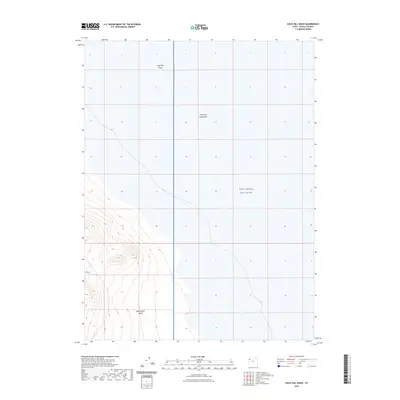
2023 Map of Gold Hill Wash
USGS Topo · Published 2023About this map
The Great Salt Lake Desert dominates the landscape of this Tooele County region, illustrating the stark topography of the eastern Great Basin. This area is defined by massive alkali flats and shifting drainage patterns, most notably the seasonal flow paths of Gold Hill Wash in the north and Rodenhouse Wash to the south. The presence of the West Desert Test Center indicates the significant military footprint in this part of Utah, where vast stretches of undeveloped terrain serve specialized government purposes. Topographic contours show the transition from the low-lying desert floor into the rising foothills of the neighboring mountains, marking where dry washes exit the high ground and fan out across the salt-crusted plains.
Find a feature on this map
4 named features on this map. Tap any name to fly to it.
Don’t see what you’re looking for? This feature index may not catch every label — zoom into the map to look around manually.
Map Details
Editions of this 2023 Gold Hill Wash Map
This is the sole edition of this map. No revisions or reprints were ever made.
Other maps of this area

1925 · Gold Hill
USGS Topo · 1:62,500

1928 · Gold Hill
USGS Topo · 1:62,500

1953 · Tooele
USGS Topo · 1:250,000

1955 · Tooele
USGS Topo · 1:250,000

1972 · Elephant Knoll SE
USGS Topo · 1:24,000
1973 · Gold Hill 4 SE
USGS Topo · 1:24,000
1973 · Gold Hill
USGS Topo · 1:24,000

1973 · Gold Hill 1 SE
USGS Topo · 1:24,000

1973 · Gold Hill 1 SW
USGS Topo · 1:24,000
1973 · Gold Hill 4 NE
USGS Topo · 1:24,000