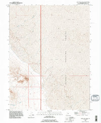
1993 Map of Gold Hill Wash
USGS Topo · Published 1996About this map
Dugway Proving Ground dominates the eastern expanse of this Tooele County landscape, where the high desert terrain transitions into a vast Mud Flat. This 1993 revision, based on imagery dating back to 1973, reveals a landscape defined by ephemeral drainage patterns and military restricted space. The western half of the sheet is marked by the winding courses of Gold Hill Wash and Rodenhouse Wash, which channel seasonal runoff from the higher elevations toward the salt-crusted basin floor. The minimal human development recorded here reflects the area's specialized use for military testing and its challenging environmental conditions. Geographers and historians can trace the specific boundaries between the public domain and the proving ground as they existed in the late twentieth century, noting the precise contour intervals that define the subtle relief of the Great Basin desert floor.
Find a feature on this map
5 named features on this map. Tap any name to fly to it.
Don’t see what you’re looking for? This feature index may not catch every label — zoom into the map to look around manually.
Map Details
Editions of this 1993 Gold Hill Wash Map
This is the sole edition of this map. No revisions or reprints were ever made.
Other maps of this area

1925 · Gold Hill
USGS Topo · 1:62,500

1928 · Gold Hill
USGS Topo · 1:62,500

1953 · Tooele
USGS Topo · 1:250,000

1955 · Tooele
USGS Topo · 1:250,000

1972 · Elephant Knoll SE
USGS Topo · 1:24,000
1973 · Gold Hill 4 SE
USGS Topo · 1:24,000
1973 · Gold Hill
USGS Topo · 1:24,000

1973 · Gold Hill 1 SE
USGS Topo · 1:24,000

1973 · Gold Hill 1 SW
USGS Topo · 1:24,000
1973 · Gold Hill 4 NE
USGS Topo · 1:24,000