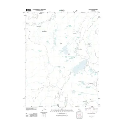
2012 Map of Gold Lake
USGS Topo · Published 2012About this map
Lakes Basin defines this high-elevation landscape, where a dense concentration of glacial tarns and alpine peaks supports a long-standing recreation economy. The map reveals a network of seasonal retreats including the Gray Eagle Lodge, Elwell Lodge, and Gold Lake Lodge, situated near the massive Gold Lake. These lodges, alongside the San Francisco Campfire Girls Camp, highlight the area's twentieth-century transition from resource extraction to a protected mountain escape. High peaks like Mount Elwell and Eureka Peak loom over the terrain, while the sheer drop of the Frazier Falls Scenic Viewpoint serves as a major landmark. The drainage patterns of Smith Cr and Frazier Cr carve through deep canyons like Florentine Canyon, and numerous meadow systems such as Hawley Meadow and Lusk Meadows dot the high plateaus between the rocky summits.
Find a feature on this map
77 named features on this map. Tap any name to fly to it.
Don’t see what you’re looking for? This feature index may not catch every label — zoom into the map to look around manually.
Map Details
Editions of this 2012 Gold Lake Map
This is the sole edition of this map. No revisions or reprints were ever made.
Other maps of this area

1891 · Downieville
USGS Topo · 1:125,000

1893 · Downieville
USGS Topo · 1:125,000

1895 · Downieville
USGS Topo · 1:125,000

1896 · Downieville
USGS Topo · 1:125,000

1897 · Downieville
USGS Topo · 1:125,000

1937 · Blairsden
USGS Topo · 1:48,000

1943 · Blairsden
USGS Topo · 1:62,500
1951 · Mt. Fillmore
USGS Topo · 1:24,000
1951 · Downieville
USGS Topo · 1:24,000
1951 · Blue Nose Mtn
USGS Topo · 1:24,000