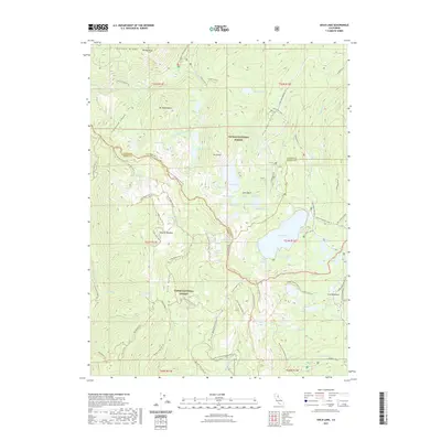
2021 Map of Gold Lake
USGS Topo · Published 2021About this map
Lakes Basin dominates this portion of the Sierra Nevada, where the high-altitude terrain is characterized by an exceptional density of glacial lakes and technical trail networks. Significant landmarks like Mt Elwell and Mt Washington overlook a landscape carved by Jamison Cr and Little Jamison Cr, while the Pacific Crest National Scenic Trl traverses the high ridges. The concentration of water bodies, including Gold Lake, Silver Lake, and Long Lake, underscores the region's importance for early alpine recreation and resource management. Evidence of long-standing human presence in the backcountry is found at the Gray Eagle Lodge and the Campground Museum Trl near the northern boundary. The map also detailes extensive off-highway vehicle routes like the Gold Valley Ohv Trl and Hawley Mine Ohv Trl, reflecting the area's transition from 19th-century mining access to modern multi-use forest management across the Plumas National Forest and Tahoe National Forest.
Find a feature on this map
86 named features on this map. Tap any name to fly to it.
Don’t see what you’re looking for? This feature index may not catch every label — zoom into the map to look around manually.
Map Details
Editions of this 2021 Gold Lake Map
This is the sole edition of this map. No revisions or reprints were ever made.
Other maps of this area

1891 · Downieville
USGS Topo · 1:125,000

1893 · Downieville
USGS Topo · 1:125,000

1895 · Downieville
USGS Topo · 1:125,000

1896 · Downieville
USGS Topo · 1:125,000

1897 · Downieville
USGS Topo · 1:125,000

1937 · Blairsden
USGS Topo · 1:48,000

1943 · Blairsden
USGS Topo · 1:62,500
1951 · Mt. Fillmore
USGS Topo · 1:24,000
1951 · Downieville
USGS Topo · 1:24,000
1951 · Blue Nose Mtn
USGS Topo · 1:24,000