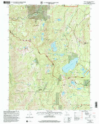
2000 Map of Gold Lake
USGS Topo · Published 2003About this map
High-altitude mining claims and mid-century recreation spots dot this landscape where the Plumas National Forest and Tahoe National Forest meet. The area is defined by the Lakes Basin, a dense collection of alpine water bodies including Gold Lake, Long Lake, and Jamison Lake. Traces of the region's industrial past are preserved at the Jamison Mine (Site) near Eureka Peak, while active resource extraction history is evident at the Four Hills Mine and Empire Mine further south. The map illustrates a transition from industrial exploitation to seasonal tourism, shown by the establishment of the Salmon Lake Resort, Gray Eagle Lodge, and the Girl Scouts Camp. Transportation routes like the historic Beckworth Downieville Trail and the Gold Lake Highway provide a framework for the movement of people and ore through the Gold Valley.
Find a feature on this map
73 named features on this map. Tap any name to fly to it.
Don’t see what you’re looking for? This feature index may not catch every label — zoom into the map to look around manually.
Map Details
Editions of this 2000 Gold Lake Map
This is the sole edition of this map. No revisions or reprints were ever made.
Other maps of this area

1891 · Downieville
USGS Topo · 1:125,000

1893 · Downieville
USGS Topo · 1:125,000

1895 · Downieville
USGS Topo · 1:125,000

1896 · Downieville
USGS Topo · 1:125,000

1897 · Downieville
USGS Topo · 1:125,000

1937 · Blairsden
USGS Topo · 1:48,000

1943 · Blairsden
USGS Topo · 1:62,500
1951 · Mt. Fillmore
USGS Topo · 1:24,000
1951 · Downieville
USGS Topo · 1:24,000
1951 · Blue Nose Mtn
USGS Topo · 1:24,000