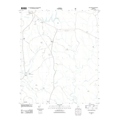
2011 Map of Gold Mine
USGS Topo · Published 2011About this map
Buttahatchee River drainage patterns define this landscape in Marion County, where the Buttahatchee Dam creates Lake Buttahatchee in the northern reaches. The area is characterized by numerous family and community burial grounds, which offer a dense record of local genealogy. These sites, such as Myers Hill Cemetery, Old Mars Hill Cemetery, and Halcomb Cemetery, are scattered across the terrain between the Little New River and Crooked Creek.
Find a feature on this map
58 named features on this map. Tap any name to fly to it.
Don’t see what you’re looking for? This feature index may not catch every label — zoom into the map to look around manually.
Map Details
Editions of this 2011 Gold Mine Map
This is the sole edition of this map. No revisions or reprints were ever made.
Other maps of this area

1936 · Delmar
USGS Topo · 1:24,000

1936 · South Of Hackleburg
USGS Topo · 1:24,000

1936 · Goddard
USGS Topo · 1:24,000

1953 · Birmingham
USGS Topo · 1:250,000

1956 · Birmingham
USGS Topo · 1:250,000

1956 · Gadsden
USGS Topo · 1:250,000

1957 · Birmingham
USGS Topo · 1:250,000

1958 · Gadsden
USGS Topo · 1:250,000
1958 · Haleyville East
USGS Topo · 1:24,000
1958 · Haleyville West
USGS Topo · 1:24,000