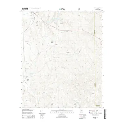
2014 Map of Gold Mine
USGS Topo · Published 2014About this map
Gold Mine and Brilliant anchor this detailed survey of the Marion County landscape, where the headwaters of the Buttahatchee River and the New River carve through the terrain. The map reveals a deeply established rural network defined by family-named cemeteries and small settlements. In the northern reaches, the W Br Buttahatchee River flows near Whitehouse, while the central portion is marked by Sunny Home and Lake Buttahatchee. The area is notably dense with burial sites of genealogical interest, including Old Poplar Springs Cem, Crooked Creek Cem, and Myers Hill Cem. Transportation relies on a web of county roads and highway corridors like Us 278, connecting isolated landmarks such as Cagle Cove to the larger towns. Water features are a dominant theme, with Little New River Lake Number 3 and Bostick Cr illustrating the complex drainage patterns of this upland region.
Find a feature on this map
62 named features on this map. Tap any name to fly to it.
Don’t see what you’re looking for? This feature index may not catch every label — zoom into the map to look around manually.
Map Details
Editions of this 2014 Gold Mine Map
This is the sole edition of this map. No revisions or reprints were ever made.
Other maps of this area

1936 · Delmar
USGS Topo · 1:24,000

1936 · South Of Hackleburg
USGS Topo · 1:24,000

1936 · Goddard
USGS Topo · 1:24,000

1953 · Birmingham
USGS Topo · 1:250,000

1956 · Birmingham
USGS Topo · 1:250,000

1956 · Gadsden
USGS Topo · 1:250,000

1957 · Birmingham
USGS Topo · 1:250,000

1958 · Gadsden
USGS Topo · 1:250,000
1958 · Haleyville East
USGS Topo · 1:24,000
1958 · Haleyville West
USGS Topo · 1:24,000