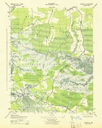
1943 Map of Golden Hill
USGS Topo · Published 1943About this map
Woolford Plantation Pt and the surrounding marshy lowlands of the Eastern Shore are documented here by the Corps of Engineers during the early 1940s. The landscape is a complex network of necks and swamps, including Peters Neck and Buttons Neck, where small settlements like Harrisville and Brooks are connected by narrow roads through the Piney Swamp. This era captures the region prior to significant modern coastal changes, showing established landings such as Walnut Ldg and topographic markers like the Church Creek Fire Lookout Tower. The emergence of conservation efforts is evident in the Blackwater National Wildlife Refuge, which spans the center of the sheet. To the south, the map details the intersection of land and water at the Honga River, featuring local navigation points like Great Marsh Creek and the small hamlet of Golden Hill.
Find a feature on this map
76 named features on this map. Tap any name to fly to it.
Don’t see what you’re looking for? This feature index may not catch every label — zoom into the map to look around manually.
Map Details
Editions of this 1943 Golden Hill Map
This is the sole edition of this map. No revisions or reprints were ever made.
Other maps of this area

1892 · Drum Point
USGS Topo · 1:62,500

1893 · Sharps Island
USGS Topo · 1:62,500

1898 · Choptank
USGS Topo · 1:125,000

1898 · St. Marys
USGS Topo · 1:125,000

1901 · Drum Point
USGS Topo · 1:62,500

1904 · Sharps Island
USGS Topo · 1:62,500

1904 · Oxford
USGS Topo · 1:62,500

1905 · Crapo
USGS Topo · 1:62,500

1905 · Drum Point
USGS Topo · 1:62,500

1906 · St. Marys
USGS Topo · 1:125,000