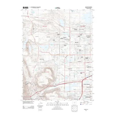
2013 Map of Golden
USGS Topo · Published 2013About this map
Golden serves as the focal point of this 2013 survey, where the valley of Clear Creek is framed by the massive basalt caps of North Table Mountain and South Table Mountain. This area reveals the complex transition from the industrial and mining heritage of the late 19th century to modern suburban development. Educational and historical foundations are prominent, from the Colorado School of Mines in the heart of Golden to the Mount Olivet Cemetery and the White Ash Mine Cem near the mountain slopes. The landscape is defined by an intricate network of irrigation and water management, featuring the Church Ditch, Wannamaker Ditch, and Croke Canal that have long sustained life on the Rocky Flats. The mapping of neighborhoods like Village of Five Parks and Applewood Village alongside landmarks like the Enterprise Grange illustrates the shifting character of Jefferson County's residential expansion.
Find a feature on this map
152 named features on this map. Tap any name to fly to it.
Don’t see what you’re looking for? This feature index may not catch every label — zoom into the map to look around manually.
Map Details
Editions of this 2013 Golden Map
This is the sole edition of this map. No revisions or reprints were ever made.
Other maps of this area

1899 · West Denver
USGS Topo · 1:125,000

1906 · Blackhawk
USGS Topo · 1:62,500

1938 · Morrison
USGS Topo · 1:24,000

1939 · Golden
USGS Topo · 1:24,000

1940 · Lafayette
USGS Topo · 1:31,680

1941 · Arvada
USGS Topo · 1:31,680

1941 · Fort Logan
USGS Topo · 1:31,680

1942 · Eldorado Springs
USGS Topo · 1:24,000

1942 · Morrison
USGS Topo · 1:31,680

1942 · Golden
USGS Topo · 1:31,680