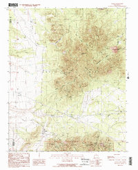
1990 Map of Golden
USGS Topo · Published 1990About this map
Mining history dominates this high-altitude landscape in the Ortiz Mountains and San Pedro Mountains. The settlement of Golden is the primary hub, surrounded by a complex network of arroyos such as Arroyo Tuerto and Arroyo Verde. The map documents a significant concentration of mineral exploration and extraction, from the storied Ortiz Mine and Old Ortiz Mine to smaller operations like Gypsy Mine and Mina del Candelario. These sites are linked by rugged infrastructure, including the historic Stagecoach Road.
Find a feature on this map
41 named features on this map. Tap any name to fly to it.
Don’t see what you’re looking for? This feature index may not catch every label — zoom into the map to look around manually.
Map Details
Editions of this 1990 Golden Map
2 editions found
Other maps of this area

1892 · San Pedro
USGS Topo · 1:125,000

1954 · Sandia Park
USGS Topo · 1:24,000

1954 · San Pedro
USGS Topo · 1:24,000

1954 · San Felipe Pueblo NE
USGS Topo · 1:24,000

1954 · Hagan
USGS Topo · 1:24,000

1954 · San Felipe Pueblo
USGS Topo · 1:62,500

1956 · Edgewood
USGS Topo · 1:62,500

1958 · Albuquerque
USGS Topo · 1:250,000

1961 · Madrid
USGS Topo · 1:62,500

1962 · Albuquerque
USGS Topo · 1:250,000