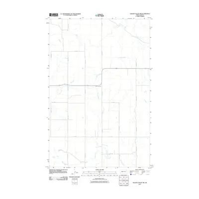
2011 Map of Golden Valley NW
USGS Topo · Published 2011About this map
Defiance Cemetery serves as a lonely landmark in this rural stretch of Mercer County, marking the transition between the agricultural plateaus and the drainage basins of the Missouri River watershed. The landscape is defined by the carved paths of Goodman Creek, Hans Creek, and Horse Creek, which wind through the township sections. A rigid grid of section roads, including 80th Ave SW and 79th St NW, segments the prairie, illustrating the enduring influence of the Public Land Survey System on North Dakota's modern geography. Centered around the intersection of County Rd-1 and the local road network, this area represents the sparsely populated heart of the northern plains, where natural drainage and farm access routes dictate the rhythm of the land.
Find a feature on this map
18 named features on this map. Tap any name to fly to it.
Don’t see what you’re looking for? This feature index may not catch every label — zoom into the map to look around manually.
Map Details
Editions of this 2011 Golden Valley NW Map
This is the sole edition of this map. No revisions or reprints were ever made.
Other maps of this area

1953 · Watford City
USGS Topo · 1:250,000

1957 · Watford City
USGS Topo · 1:250,000

1967 · Watford City
USGS Topo · 1:250,000

1967 · Raub SE
USGS Topo · 1:24,000

1967 · Twin Buttes
USGS Topo · 1:24,000

1970 · Halliday NE
USGS Topo · 1:24,000

1970 · Hay Flat
USGS Topo · 1:24,000
1970 · Golden Valley NE
USGS Topo · 1:24,000

1970 · Golden Valley NW
USGS Topo · 1:24,000

1973 · Halliday
USGS Topo · 1:24,000