
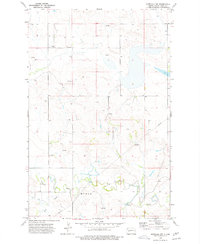
1973 Map of Halliday
USGS Topo · Published 1977About this map
Halliday sits as a primary junction of transport and trade in this mid-1970s western North Dakota landscape. The community is defined by its position along the Burlington Northern railroad line, which follows the path of Spring Creek through the northern portion of the quadrangle. Agricultural infrastructure is prominent, with several clusters of Storage Bins and a Substa supporting local operations. Local recreation and community life are grounded at the Rodeo Ground on the western edge of town.
Find a feature on this map
18 named features on this map. Tap any name to fly to it.
Don’t see what you’re looking for? This feature index may not catch every label — zoom into the map to look around manually.
Map Details
Editions of this 1973 Halliday Map
This is the sole edition of this map. No revisions or reprints were ever made.
Other maps of this area

1953 · Watford City
USGS Topo · 1:250,000

1957 · Watford City
USGS Topo · 1:250,000

1967 · Watford City
USGS Topo · 1:250,000

1970 · Halliday NE
USGS Topo · 1:24,000

1970 · Golden Valley NW
USGS Topo · 1:24,000

1970 · Halliday NW
USGS Topo · 1:24,000

1973 · Schaffner Creek
USGS Topo · 1:24,000

1973 · Dodge
USGS Topo · 1:24,000

1973 · Werner
USGS Topo · 1:24,000
1973 · Marshall NW
USGS Topo · 1:24,000