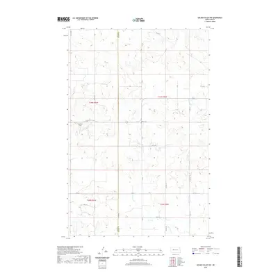
2020 Map of Golden Valley NW
USGS Topo · Published 2020About this map
Goodman Cr and Hans Cr wind through the open country of the northern plains along the border of Dunn and Mercer Counties. This landscape is defined by its section-line road network and isolated landmarks that speak to the region's agricultural and aviation history. Notable among these is the Frei Private Airport situated in the western portion of the quadrangle. Local genealogy is grounded at the Defiance Cem, which sits near the center of the sheet along the drainage of Goodman Creek. The map also traces various Bureau of Indian Affairs routes, including Bia Rd 11 and Bia Rd 26, reflecting the unique administrative history of these western lands where tribal and county jurisdictions meet.
Find a feature on this map
22 named features on this map. Tap any name to fly to it.
Don’t see what you’re looking for? This feature index may not catch every label — zoom into the map to look around manually.
Map Details
Editions of this 2020 Golden Valley NW Map
This is the sole edition of this map. No revisions or reprints were ever made.
Other maps of this area

1953 · Watford City
USGS Topo · 1:250,000

1957 · Watford City
USGS Topo · 1:250,000

1967 · Watford City
USGS Topo · 1:250,000

1967 · Raub SE
USGS Topo · 1:24,000

1967 · Twin Buttes
USGS Topo · 1:24,000

1970 · Halliday NE
USGS Topo · 1:24,000

1970 · Hay Flat
USGS Topo · 1:24,000
1970 · Golden Valley NE
USGS Topo · 1:24,000

1970 · Golden Valley NW
USGS Topo · 1:24,000

1973 · Halliday
USGS Topo · 1:24,000