
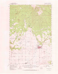
1957 Map of Goldendale
USGS Topo · Published 1959About this map
The town of Goldendale serves as the focal point for this mid-century survey of south-central Washington, situated in the valley of the Little Klickitat River. The landscape transitions from the agricultural expanses of Horseshoe Bend in the south to the high, volcanic peaks of the Simcoe Mountains in the north. This transition is marked by a series of prominent summits, including Black Butte, Jackknife Butte, and Lorena Butte Lookout, which dominates the local skyline south of the city.
Find a feature on this map
53 named features on this map. Tap any name to fly to it.
Don’t see what you’re looking for? This feature index may not catch every label — zoom into the map to look around manually.
Map Details
Editions of this 1957 Goldendale Map
2 editions found
Other maps of this area

1904 · Mount Adams
USGS Topo · 1:125,000

1907 · Mount Adams
USGS Topo · 1:125,000

1934 · The Dalles
USGS Topo · 1:125,000

1937 · White Swan
USGS Topo · 1:125,000

1950 · Yakima
USGS Topo · 1:250,000

1953 · The Dalles
USGS Topo · 1:250,000

1956 · The Dalles
USGS Topo · 1:250,000

1957 · The Dalles
USGS Topo · 1:250,000

1957 · Wasco
USGS Topo · 1:62,500

1957 · Klickitat
USGS Topo · 1:62,500