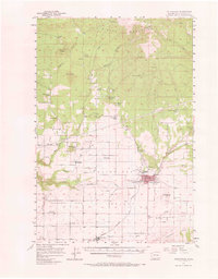
1957 Map of Goldendale
USGS Topo · Published 1966About this map
Goldendale serves as the focal point of this mid-century survey, situated at the crossroads of the Little Klickitat River and the Spokane Portland and Seattle railroad. The landscape transitions from the high elevations of the Simcoe Mountains in the north, marked by the A J Bolon Historic Monument, down into the productive Horseshoe Bend and the agricultural lands surrounding Centerville. Rural life is clearly etched into the terrain through scattered one-room schoolhouses like Firwood School and Pine Forest School, alongside local institutions such as the County Fairgrounds and the Goldendale Trout Hatchery. In the southwest, the Columbia River cuts through the southern hills, while prominent geological features like Lorena Butte & Lookout and Jackknife Butte provide distinct landmarks for early residents and navigators of the Klickitat Valley.
Find a feature on this map
53 named features on this map. Tap any name to fly to it.
Don’t see what you’re looking for? This feature index may not catch every label — zoom into the map to look around manually.
Map Details
Editions of this 1957 Goldendale Map
2 editions found

Other maps of this area

1904 · Mount Adams
USGS Topo · 1:125,000

1907 · Mount Adams
USGS Topo · 1:125,000

1934 · The Dalles
USGS Topo · 1:125,000

1937 · White Swan
USGS Topo · 1:125,000

1950 · Yakima
USGS Topo · 1:250,000

1953 · The Dalles
USGS Topo · 1:250,000

1956 · The Dalles
USGS Topo · 1:250,000

1957 · The Dalles
USGS Topo · 1:250,000

1957 · Wasco
USGS Topo · 1:62,500

1957 · Klickitat
USGS Topo · 1:62,500