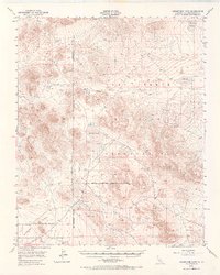
1948 Map of Goldstone Lake
USGS Topo · Published 1969About this map
Goldstone Lake and the surrounding high desert terrain define this 1948 survey of the northern Mojave, where military expansion and ephemeral lake beds characterize the landscape. The region is largely dominated by the Camp Irwin Military Reservation, with various boundaries such as the Naval Reservation Boundary and the Military Reservation Boundary (Approximate) partitioning the desert floor. These designations reflect the strategic transition of the area during and after World War II.
Find a feature on this map
10 named features on this map. Tap any name to fly to it.
Don’t see what you’re looking for? This feature index may not catch every label — zoom into the map to look around manually.
Map Details
Editions of this 1948 Goldstone Lake Map
2 editions found
Other maps of this area

1915 · Searles Lake
USGS Topo · 1:250,000

1933 · Avawatz Mountains
USGS Topo · 1:250,000

1947 · Trona
USGS Topo · 1:250,000

1948 · Trona
USGS Topo · 1:250,000

1948 · Alvord Mountain
USGS Topo · 1:62,500

1948 · Quail Mountains
USGS Topo · 1:62,500

1948 · Lane Mountain
USGS Topo · 1:62,500

1948 · Leach Lake
USGS Topo · 1:62,500

1948 · Goldstone Lake
USGS Topo · 1:62,500

1948 · Tiefort Mountains
USGS Topo · 1:62,500