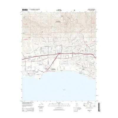
2015 Map of Goleta
USGS Topo · Published 2015About this map
The Santa Barbara coastline and the foothills of the Santa Ynez Mountains define this coastal quadrangle, where urban development meets the southern boundary of the Los Padres National Forest. The landscape is shaped by numerous seasonal watercourses like San Jose Cr and Maria Ygnacio Cr that drain into the Pacific Ocean near Goleta Point. A central corridor of activity is anchored by the Santa Barbara Municipal Airport and the sprawling campus of the University of California-Santa Barbara, which sits adjacent to the community of Isla Vista. Local history is preserved at the Goleta Cemetery and La Patera Catholic Cemetery, while the distinctive topography of Mescalitan Island and More Mesa provides insight into the geological character of the Santa Barbara Channel's edge. Residential expansion is evident in established enclaves like Hope Ranch and El Sueno, situated between the mountains and the sea.
Find a feature on this map
50 named features on this map. Tap any name to fly to it.
Don’t see what you’re looking for? This feature index may not catch every label — zoom into the map to look around manually.
Map Details
Editions of this 2015 Goleta Map
This is the sole edition of this map. No revisions or reprints were ever made.
Other maps of this area

1902 · Santa Ynez
USGS Topo · 1:125,000

1905 · Santa Ynez
USGS Topo · 1:125,000

1941 · San Rafael Mtn.
USGS Topo · 1:62,500

1942 · Goleta
USGS Topo · 1:62,500

1942 · San Rafael Mtn.
USGS Topo · 1:62,500

1942 · Little Pine Mountain
USGS Topo · 1:24,000

1943 · San Rafael Mtn.
USGS Topo · 1:62,500

1944 · Santa Barbara
USGS Topo · 1:31,680
1944 · Little Pine Mountain
USGS Topo · 1:31,680

1949 · Los Angeles
USGS Topo · 1:250,000