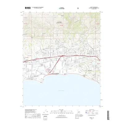
2018 Map of Goleta
USGS Topo · Published 2018About this map
The Santa Ynez Mountains rise sharply above the coastal shelf, defining the dramatic geography of this Santa Barbara County coastline. The Los Padres National Forest occupies the high ground to the north, while the lower elevations are shaped by the development of Goleta and the sprawling campus of the Univ of California-Santa Barbara. The presence of the Santa Barbara Municipal Airport and the complex wetlands of the Goleta Slough highlight the intersection of mid-century infrastructure and sensitive coastal ecosystems. Along the shore, landmarks such as Mescalitan Island and Goleta Point separate the student residential area of Isla Vista from the upscale residential estates of Hope Ranch and the open space at More Mesa. This period shows a landscape deeply connected by US Highway 101 and the Union Pacific railroad corridor.
Find a feature on this map
220 named features on this map. Tap any name to fly to it.
Don’t see what you’re looking for? This feature index may not catch every label — zoom into the map to look around manually.
Map Details
Editions of this 2018 Goleta Map
This is the sole edition of this map. No revisions or reprints were ever made.
Other maps of this area

1902 · Santa Ynez
USGS Topo · 1:125,000

1905 · Santa Ynez
USGS Topo · 1:125,000

1941 · San Rafael Mtn.
USGS Topo · 1:62,500

1942 · Goleta
USGS Topo · 1:62,500

1942 · San Rafael Mtn.
USGS Topo · 1:62,500

1942 · Little Pine Mountain
USGS Topo · 1:24,000

1943 · San Rafael Mtn.
USGS Topo · 1:62,500

1944 · Santa Barbara
USGS Topo · 1:31,680
1944 · Little Pine Mountain
USGS Topo · 1:31,680

1949 · Los Angeles
USGS Topo · 1:250,000