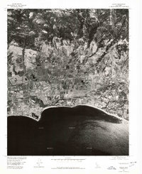
1976 Map of Goleta
USGS Topo · Published 1978About this map
The coastal plain of Southern California is documented here via aerial photography captured in 1976. The orthophotoquad format reveals the physical expansion of Goleta during a period of rapid development, showcasing the structured geometry of its residential neighborhoods, agricultural fields, and industrial parcels. Along the shoreline, the developed estates of Hope Ranch contrast with the open water of the Santa Barbara Channel. This hybrid map-and-photo format allows for a precise study of 1970s land use, tracing how San Jose Creek and other drainage patterns intersect with the built environment and the Pacific Ocean coastline. It provides an unfiltered record of the region’s topography before further decades of infill and suburban densification altered the coastal character.
Find a feature on this map
5 named features on this map. Tap any name to fly to it.
Don’t see what you’re looking for? This feature index may not catch every label — zoom into the map to look around manually.
Map Details
Editions of this 1976 Goleta Map
This is the sole edition of this map. No revisions or reprints were ever made.
Other maps of this area

1902 · Santa Ynez
USGS Topo · 1:125,000

1905 · Santa Ynez
USGS Topo · 1:125,000

1941 · San Rafael Mtn.
USGS Topo · 1:62,500

1942 · Goleta
USGS Topo · 1:62,500

1942 · San Rafael Mtn.
USGS Topo · 1:62,500

1942 · Little Pine Mountain
USGS Topo · 1:24,000

1943 · San Rafael Mtn.
USGS Topo · 1:62,500

1944 · Santa Barbara
USGS Topo · 1:31,680
1944 · Little Pine Mountain
USGS Topo · 1:31,680

1949 · Los Angeles
USGS Topo · 1:250,000