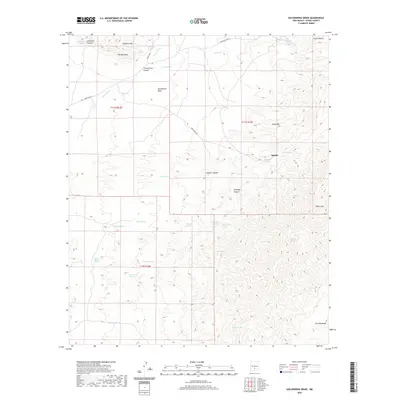
2020 Map of Golondrina Draw
USGS Topo · Published 2020About this map
Sierra Blanca anchors the northeastern corner of this Otero County landscape, where the high terrain gives way to a network of canyons and intermittent water sources. The small settlement of Apache is positioned among a cluster of springs including Valdez Spring, Montoya Spring, and Mustang Spring, illustrating how historical movement and habitation in this arid region were dictated by access to water. Significant geological formations like The Palisades and Godfrey Hills rise above the drainage of Three Rivers, while the southern expanse is defined by the broad Salinas Draw. This map captures a remote area of New Mexico's interior, showing a landscape shaped by rugged elevation changes from Horse Mtn down into the deep recesses of Barber Canyon and Montoya Canyon. The presence of established routes like Indian Svc Rte 23 and Golondrina Rd suggests the continuing utility of these paths through the basin-and-range territory.
Find a feature on this map
40 named features on this map. Tap any name to fly to it.
Don’t see what you’re looking for? This feature index may not catch every label — zoom into the map to look around manually.
Map Details
Editions of this 2020 Golondrina Draw Map
This is the sole edition of this map. No revisions or reprints were ever made.
Other maps of this area
1916 · Tularosa
USGS Topo · 1:125,000
1947 · Three Rivers
USGS Topo · 1:62,500
1948 · Tularosa
USGS Topo · 1:62,500
1950 · Three Rivers
USGS Topo · 1:24,000
1950 · Oscura
USGS Topo · 1:24,000
1950 · Sierra Blanca Peak
USGS Topo · 1:62,500
1950 · Mescalero
USGS Topo · 1:62,500
1954 · Tularosa
USGS Topo · 1:250,000
1955 · Roswell
USGS Topo · 1:250,000
1958 · Roswell
USGS Topo · 1:250,000