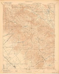
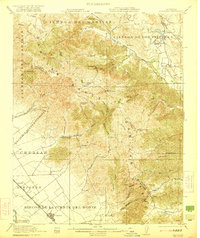
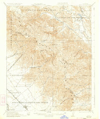
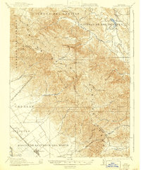
1921 Map of Gonzales
USGS Topo · Published 1921About this map
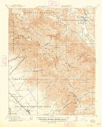
Cienega del Gabilan and the Gabilan Range dominate this 1921 study of the rugged transition between the San Benito River valley and the Salinas drainage. The map reveals a landscape defined by large Spanish-named land grants like Rincon de la Puente del Monte and Encinal y Buena Esperanza. Along the western edge, the Southern Pacific railroad corridor anchors the growing settlement of Gonzales, while the eastern side of the mountains shows the more dispersed ranching life centered around Paicines and the Paicines Ranch. Education in these remote canyons is marked by a network of rural schoolhouses, including Cienega School, Canyon School, and Gloria School. Industrial activity is represented by the Dolomite Quarry near the northern boundary, reflecting the mineral extraction that complemented the region's agricultural and grazing economy.
Find a feature on this map
68 named features on this map. Tap any name to fly to it.
Don’t see what you’re looking for? This feature index may not catch every label — zoom into the map to look around manually.
Map Details
Editions of this 1921 Gonzales Map
5 editions found
Other maps of this area

1910 · Gonzales
USGS Topo · 1:31,680

1910 · Salinas
USGS Topo · 1:31,680

1910 · Soledad
USGS Topo · 1:31,680

1912 · Salinas
USGS Topo · 1:62,500

1915 · Soledad
USGS Topo · 1:62,500

1915 · San Juan Bautista
USGS Topo · 1:48,000

1917 · San Juan Bautista
USGS Topo · 1:62,500

1919 · San Benito
USGS Topo · 1:62,500

1919 · Hollister
USGS Topo · 1:48,000

1920 · Jamesburg
USGS Topo · 1:48,000