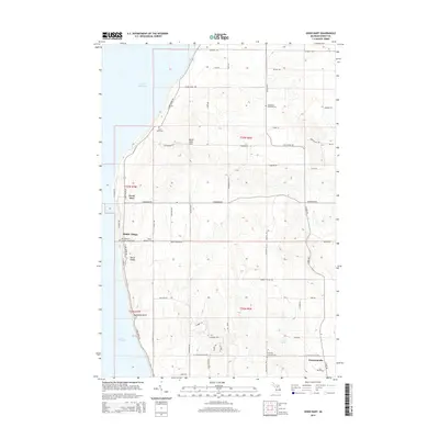
2014 Map of Good Hart
USGS Topo · Published 2014About this map
Good Hart and Middle Village anchor this coastal reach of Emmet County, where the topography rises sharply from the eastern shore of Lake Michigan. The landscape is defined by its high bluffs and complex glacial terrain, featuring prominent landmarks like Island View Hill and the dramatic shoreline turns at Devils Elbow and Horseshoe Bend. Inland, the settlement of Stutsmanville sits near the intersection of S State Rd and Walker Rd, surrounded by a network of rural routes such as Middle Village Rd and W Robinson Rd. For local historians and genealogists, the map provides precise locations for several faith-based and municipal burial grounds, including the Saint Ignatius Catholic Chuch Cem and Beran Baptist Cem in Middle Village, as well as the Readmond Township Cem and Frienship Township Cem further east. The presence of Morris Spring and numerous unnamed drainages highlights the area's natural hydrology between the coast and the elevated interior.
Find a feature on this map
60 named features on this map. Tap any name to fly to it.
Don’t see what you’re looking for? This feature index may not catch every label — zoom into the map to look around manually.
Map Details
Editions of this 2014 Good Hart Map
This is the sole edition of this map. No revisions or reprints were ever made.
Other maps of this area

1955 · Cheboygan
USGS Topo · 1:250,000

1958 · Cheboygan
USGS Topo · 1:250,000

1958 · Cross Village
USGS Topo · 1:62,500

1958 · Pellston
USGS Topo · 1:62,500

1958 · Bayshore
USGS Topo · 1:62,500

1958 · Petoskey
USGS Topo · 1:62,500

1975 · Petoskey NW
USGS Topo · 1:24,000

1982 · Petoskey
USGS Topo · 1:100,000
1982 · Bliss
USGS Topo · 1:25,000
1982 · Good Hart
USGS Topo · 1:25,000
Featured Places
- Stutsmanville, MI
- Good Hart, MI
- Cross Village Township, MI
- Friendship Township, MI
- Readmond Township, MI