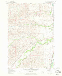
1967 Map of Good Luck Creek
USGS Topo · Published 1971About this map
The Little Bighorn River corridor and its surrounding drainage systems define this 1967 portrait of the Crow Indian Reservation. The landscape is marked by a complex network of irrigation infrastructure, specifically the Lodge Grass Canal No 1 and Lodge Grass Canal No 2, which trace the contours of the valley to support agriculture along Lodge Grass Creek. In the eastern section, the Chicago Burlington and Quincy railroad follows the river's path, providing a vital transportation link through Big Horn County.
Find a feature on this map
19 named features on this map. Tap any name to fly to it.
Don’t see what you’re looking for? This feature index may not catch every label — zoom into the map to look around manually.
Map Details
Editions of this 1967 Good Luck Creek Map
This is the sole edition of this map. No revisions or reprints were ever made.
Other maps of this area

1894 · Rosebud
USGS Topo · 1:125,000

1894 · St. Xavier
USGS Topo · 1:125,000

1901 · Rosebud
USGS Topo · 1:125,000

1901 · St. Xavier
USGS Topo · 1:125,000

1954 · Hardin
USGS Topo · 1:250,000

1957 · Hardin
USGS Topo · 1:250,000

1958 · Hardin
USGS Topo · 1:250,000

1960 · Schick Ranch
USGS Topo · 1:24,000

1960 · St Xavier NE
USGS Topo · 1:24,000

1967 · Lodge Grass NE
USGS Topo · 1:24,000