
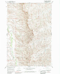
1960 Map of Schick Ranch
USGS Topo · Published 1962About this map
Rotten Grass Creek winds through this section of the Missouri River Basin, defining a landscape of deep coulees and seasonal waterways in Big Horn County. The settlement pattern here is characterized by isolated homesteads like Schick Ranch and Barber Ranch, which are connected by a network of jeep trails navigating the high-relief terrain. The map captures the hydrological complexity of the area, where Mission Coulee and Ash Coulee drain into larger valleys. High points such as VABM Schick 4340 and VABM Bear 4070 provide orientation markers for the ranching operations established along the drainage systems of Good Luck Creek and the forks of South Sand Creek. These features reflect the era's land use, where water access and elevation dictated the placement of rural outposts.
Find a feature on this map
17 named features on this map. Tap any name to fly to it.
Don’t see what you’re looking for? This feature index may not catch every label — zoom into the map to look around manually.
Map Details
Editions of this 1960 Schick Ranch Map
2 editions found
Other maps of this area

1894 · Rosebud
USGS Topo · 1:125,000

1894 · St. Xavier
USGS Topo · 1:125,000

1901 · Rosebud
USGS Topo · 1:125,000

1901 · St. Xavier
USGS Topo · 1:125,000

1954 · Hardin
USGS Topo · 1:250,000

1957 · Hardin
USGS Topo · 1:250,000

1958 · Hardin
USGS Topo · 1:250,000

1960 · St Xavier
USGS Topo · 1:24,000

1960 · St Xavier NE
USGS Topo · 1:24,000

1960 · Mission Coulee
USGS Topo · 1:24,000