
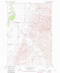
1960 Map of St Xavier
USGS Topo · Published 1962About this map
St Xavier sits at the transition between the fertile bottomlands of the Bighorn River and the undulating breaks of the Mission Buttes in the early 1960s. This survey, conducted for the Missouri River Basin development program, details a landscape defined by the intersection of natural waterways and managed irrigation. The Big Horn Canal cuts across the plains to support local agriculture, while Rotten Grass Creek meanders toward the river. Cultural landmarks of the period include the St John Ch, which serves as a focal point for the rural community. The map also documents the intricate drainage system of the area, featuring uniquely named terrain such as Yoke Coulee and East Dipping Vat Coulee, reflecting local ranching and geographical history.
Find a feature on this map
15 named features on this map. Tap any name to fly to it.
Don’t see what you’re looking for? This feature index may not catch every label — zoom into the map to look around manually.
Map Details
Editions of this 1960 St Xavier Map
2 editions found
Other maps of this area

1894 · St. Xavier
USGS Topo · 1:125,000

1894 · Fort Custer
USGS Topo · 1:125,000

1901 · St. Xavier
USGS Topo · 1:125,000

1954 · Hardin
USGS Topo · 1:250,000

1957 · Hardin
USGS Topo · 1:250,000

1958 · Hardin
USGS Topo · 1:250,000

1960 · Schick Ranch
USGS Topo · 1:24,000

1960 · St Xavier NE
USGS Topo · 1:24,000

1960 · Mission Coulee
USGS Topo · 1:24,000
1960 · Prante Ranch
USGS Topo · 1:24,000