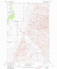
1960 Map of St Xavier
USGS Topo · Published 1980About this map
The settlement of St Xavier and the nearby St John Ch serve as focal points for this survey of the Big Horn Valley during the mid-20th century. The landscape is defined by the powerful north-flowing Bighorn River and the complex irrigation network of the Big Horn Canal, which parallels the river along the valley floor. The surrounding terrain is deeply carved by numerous drainages, including the lengthy Rotten Grass Creek and the family-named Del Howe Coulee. To the east, the Mission Buttes provide a distinct topographic break from the undulating coulees and grazing lands. The presence of several Gravel Pits and various pits throughout the hills suggests the importance of local material extraction for maintaining the area's rural road network. This map offers a clear view of the Crow Indian Reservation landscape as it appeared before the significant changes of the late 20th century.
Find a feature on this map
17 named features on this map. Tap any name to fly to it.
Don’t see what you’re looking for? This feature index may not catch every label — zoom into the map to look around manually.
Map Details
Editions of this 1960 St Xavier Map
2 editions found
Other maps of this area

1894 · St. Xavier
USGS Topo · 1:125,000

1894 · Fort Custer
USGS Topo · 1:125,000

1901 · St. Xavier
USGS Topo · 1:125,000

1954 · Hardin
USGS Topo · 1:250,000

1957 · Hardin
USGS Topo · 1:250,000

1958 · Hardin
USGS Topo · 1:250,000

1960 · Schick Ranch
USGS Topo · 1:24,000

1960 · St Xavier
USGS Topo · 1:24,000

1960 · St Xavier NE
USGS Topo · 1:24,000

1960 · Mission Coulee
USGS Topo · 1:24,000