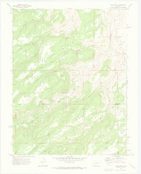
1969 Map of Good Point
USGS Topo · Published 1973About this map
Petroglyphs located along the eastern edge of the Escalante Rim signal a human presence on this high plateau landscape long before modern mapping. The terrain is characterized by a series of prominent high-altitude plateaus and benches, including Dry Mesa, Little Dry Mesa, and Mc Carty Bench. Water management in this arid environment is evident through several named sources such as Cottonwood Spring, Alum Spring, and Porter Spring, alongside constructed features like Dry Mesa Reservoir No 2 and Stone Basin Reservoir. Historical travel across these ridges was largely dependent on primitive routes like the Sawmill Trail and various pack trails. The boundary between Delta County and Montrose County bisects the southern portion of the map, illustrating how local jurisdiction was partitioned across these high-country gulches and ridges.
Find a feature on this map
29 named features on this map. Tap any name to fly to it.
Don’t see what you’re looking for? This feature index may not catch every label — zoom into the map to look around manually.
Map Details
Editions of this 1969 Good Point Map
4 editions found
Other maps of this area

1956 · Moab
USGS Topo · 1:250,000

1959 · Moab
USGS Topo · 1:250,000

1960 · Moab
USGS Topo · 1:250,000

1962 · Moab
USGS Topo · 1:250,000

1964 · Moab
USGS Topo · 1:250,000

1965 · Moab
USGS Topo · 1:250,000
1965 · Point Creek
USGS Topo · 1:24,000
1969 · Roubideau
USGS Topo · 1:24,000
1969 · Triangle Mesa
USGS Topo · 1:24,000
1969 · Dominguez
USGS Topo · 1:24,000