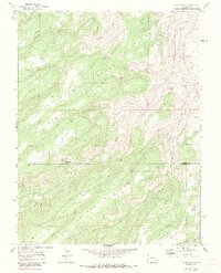
1969 Map of Good Point
USGS Topo · Published 1991About this map
Escalante Creek carves a deep path through the canyon lands of the Uncompahgre Plateau, marking the border between Delta and Montrose counties. This 1969 field-checked survey reveals a landscape defined by sharp topographical features like Good Point, Bad Point, and the prominent Escalante Rim. The network of (Pack) Trail routes and 4WD tracks suggests a territory accessed primarily by stockmen and explorers, with vital water sources such as Caps Spring and Cottonwood Spring supporting life in the arid high country. Evidence of earlier inhabitants is noted along the eastern cliffs where Petroglyphs are marked, while the presence of the Dry Mesa Reservoir No 2 and Stone Basin Reservoir indicates modern efforts to manage the scarce water resources of Little Dry Mesa. The terrain is divided into long, narrow ridges including Sowbelly Ridge and Camp Ridge, separated by a series of steep drainages like Palmer Gulch and Tatum Gulch.
Find a feature on this map
31 named features on this map. Tap any name to fly to it.
Don’t see what you’re looking for? This feature index may not catch every label — zoom into the map to look around manually.
Map Details
Editions of this 1969 Good Point Map
4 editions found
Other maps of this area

1956 · Moab
USGS Topo · 1:250,000

1959 · Moab
USGS Topo · 1:250,000

1960 · Moab
USGS Topo · 1:250,000

1962 · Moab
USGS Topo · 1:250,000

1964 · Moab
USGS Topo · 1:250,000

1965 · Moab
USGS Topo · 1:250,000
1965 · Point Creek
USGS Topo · 1:24,000
1969 · Roubideau
USGS Topo · 1:24,000
1969 · Triangle Mesa
USGS Topo · 1:24,000
1969 · Dominguez
USGS Topo · 1:24,000