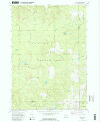
1972 Map of Goodar
USGS Topo · Published 1989About this map
The Au Sable River cuts through the northern portion of this landscape, a region largely defined by the protected lands of the Huron National Forest. This 1972 survey reveals a terrain shaped by water and historical transit, with numerous wetlands and small water bodies such as Hughes Lake, Emley Lake, and the cluster known as Three Lakes. Evidence of earlier timber or industrial operations is preserved through the network of named primitive routes like Evans Grade and a decommissioned Railroad Grade that winds through the southern sections near the settlement of Goodar. The map detail captures a specific moment where the boundaries of Oscoda, Alcona, Ogemaw, and Iosco counties meet, showing a transition from dense forest to the headwaters of Stewart Creek and South Branch Smith Creek. Several gravel pits scattered across Mentor and Curtis townships indicate local resource extraction during this era.
Find a feature on this map
33 named features on this map. Tap any name to fly to it.
Don’t see what you’re looking for? This feature index may not catch every label — zoom into the map to look around manually.
Map Details
Editions of this 1972 Goodar Map
3 editions found
Other maps of this area

1954 · Traverse City
USGS Topo · 1:250,000

1954 · Tawas City
USGS Topo · 1:250,000

1958 · Traverse City
USGS Topo · 1:250,000

1958 · Tawas City
USGS Topo · 1:250,000

1965 · Rose City
USGS Topo · 1:24,000

1968 · Hale
USGS Topo · 1:24,000

1968 · South Branch
USGS Topo · 1:24,000

1972 · McKinley
USGS Topo · 1:24,000

1972 · Curran
USGS Topo · 1:24,000

1972 · Goodar
USGS Topo · 1:24,000