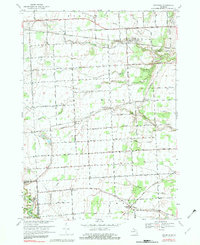
1968 Map of Goodells
USGS Topo · Published 1982About this map
The Grand Trunk Western railroad cuts across this rural St. Clair County landscape, serving the settlement of Goodells and connecting the region's agricultural fields to wider markets. The area is defined by a complex network of man-made and natural waterways, including the South Branch Pine River, Smiths Creek, and numerous drainage systems like the Johnson Drain and Apply Drain that manage the low-lying terrain. Local life in the late 1960s centered on crossroads like Wales Center and spiritual hubs such as Mt Pleasant Ch and St Philip Ch. In the southern portion, the Belle River meanders toward the Columbus area, while the northwest corner is anchored by the Kenockee Cem. This survey also shows the transition of land use, from the managed forests of the Port Huron State Game Area to active extraction sites like the Gravel Pits and a scattered Gas Well.
Find a feature on this map
51 named features on this map. Tap any name to fly to it.
Don’t see what you’re looking for? This feature index may not catch every label — zoom into the map to look around manually.
Map Details
Editions of this 1968 Goodells Map
2 editions found
Other maps of this area

1914 · Armada
USGS Topo · 1:62,500

1928 · Armada
USGS Topo · 1:62,500

1928 · Hicky
USGS Topo · 1:62,500

1936 · Rattle Run
USGS Topo · 1:31,680

1939 · Adair
USGS Topo · 1:24,000

1939 · Smiths Creek
USGS Topo · 1:24,000

1939 · Goodells
USGS Topo · 1:24,000

1942 · Rattle Run
USGS Topo · 1:24,000

1944 · Memphis
USGS Topo · 1:24,000

1945 · Richmond
USGS Topo · 1:24,000