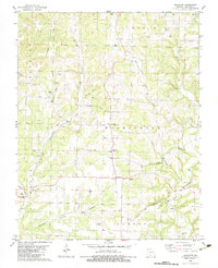
1982 Map of Goodhope
USGS Topo · Published 1983About this map
Goodhope and its surrounding countryside are defined by a network of hollows and ridges in the early 1980s. The landscape is dotted with ancestral burial grounds, including Lakey Cem, Arden Cem, and Stillings Cem, providing vital clues for genealogists tracking Ozark families. Waterways such as Beaver Creek and Honey Creek carve through the terrain, while landmarks like Keyger Mountain anchor the western boundary. Local religious life is centered around several country churches, notably Breeden Ch and Union Ch. Down in the southern valleys, Jackson Mill and the nearby Gravel Pits suggest a history of small-scale industry along the creeks. The map shows a region of scattered farmsteads and rural crossroads, where names like Arden and Roy mark tiny centers of activity amidst the intricate drainage patterns of Eslick Hollow and Sixteenth Hollow.
Find a feature on this map
44 named features on this map. Tap any name to fly to it.
Don’t see what you’re looking for? This feature index may not catch every label — zoom into the map to look around manually.
Map Details
Editions of this 1982 Goodhope Map
This is the sole edition of this map. No revisions or reprints were ever made.
Other maps of this area

1936 · Ava
USGS Topo · 1:48,000

1937 · Bradleyville
USGS Topo · 1:48,000

1939 · Fordland
USGS Topo · 1:62,500

1942 · Fordland
USGS Topo · 1:62,500

1942 · Ava
USGS Topo · 1:62,500

1943 · Bradleyville
USGS Topo · 1:62,500

1945 · Ava
USGS Topo · 1:62,500

1945 · Harrison
USGS Topo · 1:250,000

1945 · Bradleyville
USGS Topo · 1:62,500

1949 · Harrison
USGS Topo · 1:250,000