
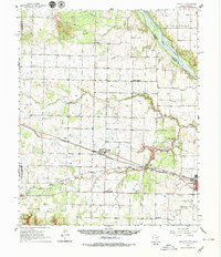
1960 Map of Goodlett
USGS Topo · Published 1962About this map
Quanah serves as a primary hub in the southeastern corner of this region, where the Fort Worth and Denver and the Pacific and Denver rail lines converge. The landscape is defined by the winding course of the Red River forming the border with Oklahoma, punctuated by numerous creek systems including North Groesbeck Creek and Squaw Creek. Smaller rural communities like Goodlett, Punkin Center, and Lazare are connected by a network of roads and rail spurs, including the Acme and Pacific.
Find a feature on this map
37 named features on this map. Tap any name to fly to it.
Don’t see what you’re looking for? This feature index may not catch every label — zoom into the map to look around manually.
Map Details
Editions of this 1960 Goodlett Map
2 editions found
Other maps of this area

1927 · Quanah 3-a
USGS Topo · 1:48,000

1927 · Quanah 3-b
USGS Topo · 1:48,000

1932 · Vivian
USGS Topo · 1:62,500

1954 · Plainview
USGS Topo · 1:250,000

1955 · Lawton
USGS Topo · 1:250,000

1958 · Plainview
USGS Topo · 1:250,000

1958 · Medicine Mound
USGS Topo · 1:62,500

1960 · Teacup Mountain
USGS Topo · 1:62,500

1960 · Loco
USGS Topo · 1:62,500

1960 · Quanah
USGS Topo · 1:62,500